
Collecting
Geospatial data
MLG is using geospatial data to go farther than mapping. We are unpacking the information of the land to create social solutions for the world.
Geographic Information
Systems and MLG
Maps began shaping our world dating far back to classical antiquity era. Subsequent versions continued to become increasingly accurate, especially with the age of exploration. In modern days, our maps have adapted so much with technology that data garnered from land information is no longer a tool to go from A-B, but rather, can offer predictive qualities for the future story of the land. MLG is using the GIS tools of today to get a preview of the future. Our geospatial data is solving big problems in order to pave the way for a brighter future.
.png)
.png)
What is
Geospatial Data?
Geospatial data is data that relates explicitly to a location on the surface of Earth. It provides valuable insights into geographic patterns and relationships, which can be used to improve decision-making in a variety of industries and applications.
These benefits include the ability to analyze spatial relationships, identify trends and patterns, optimize routes and logistics, manage natural resources, and create custom maps and visualizations. Geospatial data can also be used for disaster response and emergency management, urban planning, and environmental monitoring.


Urban Planning
Facilitating urban planning by providing valuable insights and visualization of city infrastructures, demographics, and land-use to support informed decisions.
Agriculture Planning
Cultivating agriculture planning by providing insights and visualization of crop growth patterns, soil fertility, water usage, and land-use for optimizing farming practices and minimizing environmental impacts.
Climate Change
Tracking climate change by analyzing and visualizing patterns and changes in environmental data such as temperature, precipitation, sea level rise, and carbon emissions.
Opportunities created by GIS include
(but are in no way limited to):
-
Municipal planning and management-
-
City planning
-
TourismWealth generation by land exploration opportunities ie. Mining or proper agricultural planning
-
Climate change adaptation/ mitigation
-
Security management
What will your land do for you?
Can we provide a better future for the next generation? Can we create an impact for society right now?
FUTURE POSSIBILITIES

(MLG and our partner Arce Rojas, field work in Colombia)
GIS Process at
Medici Land Governance

Data Collection
This involves gathering relevant data from various sources such as satellites, surveys, and databases.

Data Input
This involves entering the collected data into the GIS using various methods, such as manual data entry, GPS devices, or other automated data capture tools.

Data Management
This involves organizing and managing the data within the GIS, including cleaning and standardizing the data, creating metadata, and ensuring data quality.
.png)
Data Analysis
This involves using GIS tools to analyze and interpret the data, including mapping, geocoding, spatial analysis, and statistical analysis.
.png)
Data Visualization
This involves creating maps and other visual representations of the data to make it easier to understand and communicate the results of the analysis.

Data Dissemination
This involves sharing the results of the analysis with stakeholders, such as policymakers, researchers, or the general public, through reports, presentations, or interactive online platforms.
These steps are often iterative and may involve revisiting and refining previous steps as new data or insights become available.

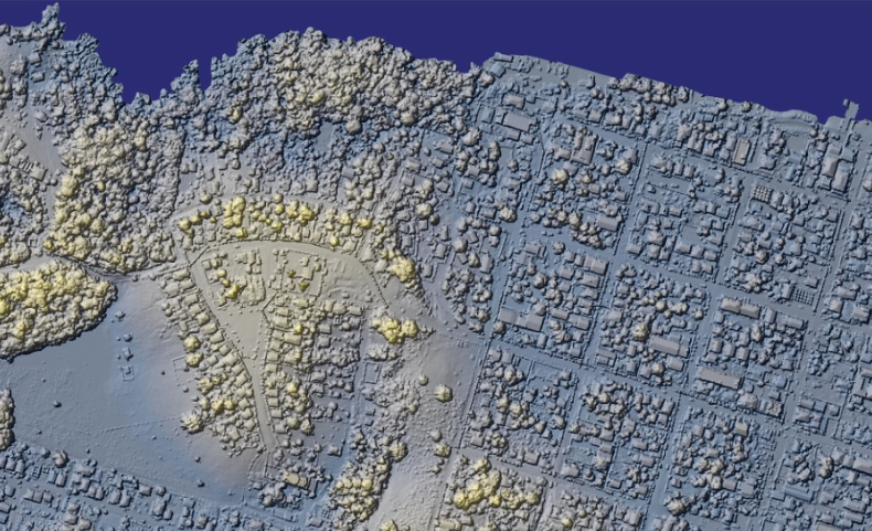
GUYANA
LIDAR ACQUISITION PROJECT
MLG is using aircraft carrying lidar sensors and mapping cameras to collect highly accurate and detailed lidar and orthophoto maps of the land surface. Following imagery capture, MLG will process this data to produce digital terrain models and map imagery for extracting infrastructure, water features, and 3D building models.
The resulting data – terrain, aerial imagery, and extracted features – will become key layers in the national map. The project covers 545 km2 of urbanized area (nearly all of Guyana’s urban footprint) and another 15,736 km2 of rural area.
How We Work
GIS
MLG’s GIS operations support all of our suite of products and services, including Systematic Land Titling, Parcel Enumeration, and Property Valuation.
MLG acquires spatial data in a variety of ways. We have deep expertise with capture of aerial imagery and lidar point clouds, using sensors carried by drones, manned aircraft, and satellites. We also capture geodata directly on the ground, using GNSS survey gear, geolocation-enabled cameras, and mobile data collection apps. We also have expertise in digitizing and geolocating legacy paper documents that relate to particular geographic locations – a classic example here is legacy title or survey documents.


.01

Unclassified lidar point clouds, containing millions of individual 3d locations, measured using the lidar system.
.02

From the raw point clouds, we can produce a "Digital Surface Model" or DSM, that represents the upper-most surface of everything surveyed (including tree canopies, buildings, and bare ground).
.03

Individual lidar points are classified or categorized into a set of industry-standard classes, including ground, buildings, water, vegetation, etc.
.04

By filtering out points belonging to classes other than ground, we can produce a "Digital Terrain Model" that represents the shape of the earth surface itself. This is valuable for modeling water flows, grading volumes needed in construction projects, etc.
Lidar data capture typically results in a sequence of direct data products:
MLG has deep experience assisting national partners in expanding and updating key elements of their national spatial data infrastructures (NSDI) via modern, high-precision, and high-accuracy topographic surveys. Our projects have covered significant portions of customers’ national territory, including urbanized areas and high-value rural areas. Surveying at this large scale is not cost-effective using legacy survey methods. An aerial survey using modern LiDAR technologies allows for accurate, rapid, and consistent surveying and producing subsequent derived data products.
Ortho-imagery and LiDAR data
From the resulting data, we can generate a wide range of further geodata products. These may include terrain models, property boundaries, building footprints, transportation networks, surface water boundaries, power and telecom infrastructure, and others. The rich variety of our geodata can be combined with other planning data (e.g., zoning, commercial areas, service areas, etc.) supplied by our customers as crucial elements to be utilized in our various services.
For example, aerial imagery together with derived parcel boundaries, infrastructure amenities, and building envelope parameters are used as inputs for MLG’s machine-learning-driven property valuation solution.
